I was anxious for cell phone coverage (and breakfast); GPS found both in Liberty, NY. Getting there via Parksville, NY involves this brand new interchange which has been carved from the bedrock. It seems like a whole lot of rock to move just to make getting on and off 17 a little easier. Google hasn't even street-viewed this spot yet - this is a brand new section of highway.
Backtracking to the Willowemoc Creek campsite on Pole Rd and beyond, I passed this spot. Luckily it was early in the day and I reasoned that stopping at this sort of thing is a big part of the reason I'm riding.
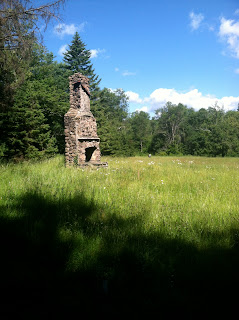
GPS tracks claim N41 55.607, W74 37.524. A big field with nothing but a standing hearth and chimney. How do you not stop to check that out? A sign leaning against the back of chimney simply proclaims, "Tommy's Land." If I were a stealth camper, this is would be a great spot. Can't help but wonder at the personal history of this site.
From the road:
Side opposite the road.
Looking back from the chimney to the bike at the edge of the road.
On Pole Rd to Frost Valley Rd/47 (a fantastic road following a stream), another GPS screw-up/ detour/ backtrack, and I eventually come out to 28/ 30, stopping for gas, water, and coffee at Arkville.
I remember 30 being a fantastic road from last year's Catskills trip which I couldn't enjoy due to lots of rain, wet leaves and sketchy tires. Having another crack at this road is a big reason I re-visited the Catskills.
The dirt roads and Frost Valley Rd will probably pull me back again.
At some point I texted Mark about possibly meeting in Wellsboro to camp the PA Grand Canyon that night. Plans to drop the PA tag at the extreme northeast corner of PA were also laid: and not even requiring a big detour, the drop is made.
With arrangements made to contact Mark at 3pm, I need to put a lot of miles behind me. 17 across NY is a slab/ slog. I pop back down into Sayre, PA, at 2:50 and find a Burger King with cell service to contact Mark, who has already texted me he won't be meeting me. I plot a course to Wellsboro.
Having stopped at "Tommy's Land," taken an accidental GPS detour (again), and diverted to drop the ADV tag, daylight is dwindling.
An annoying number of miles behind slow Florida plates: I did 6 miles of rolling farmland dotted with gas wells standing on the pegs (rt 4014 to rt 6). A caravan of truck, RV, and a few cars takes a few miles to overtake out of Wellsboro, and finally I'm on 660. It's the third longest day of the year, so there's plenty of light left as I'm climbing the few miles of Forest Road which peak at Colton Point, where I'll be camping for the night.
I register and set up, meet my camp neighbor Howard, who has pedaled his bicycle from OHIO to the PA Grand Canyon. A native Californian, he's happy to get PA touring advice from a "local." He tells me there's cell service at the lookout.
And you just don't go to this spot without taking the obligatory pics. This is a VERY photographed spot (google "PA Grand Canyon" / images) but photos just can't communicate the scale and awe of vistas like this, IMO. Very similar to Hyner View, and worth a few minutes' stroll from camp.
Looking South:
North:
I contemplated that view for 15 minutes or so, enjoying complete solitude, listening to nature, and just digging the trip and yet another day of riding in front of me when the inevitable roar of Harleys closed in on me. Soon I was sharing the lookout with a group of people who were very loud, crude, and thought themselves far more interesting than they were. That's not a rant against "Harley people," it's a rant against these PARTICULAR "Harley people."
To my dismay, Colton Point had posted signs warning that the water is contaminated and should be boiled. Earlier in Arkville, when I was checking out with my coffee, I told the register woman that I'd also taken some water, and joked whether it was free. She was quick to ask which faucet I'd used, as only one is filtered/ potable. On my way home on the last trip, I stopped in Lawrenceville for gas/ water only to find out they didn't have potable tap water, either. Putting aside all the questions this trio of experiences raises, I've decided to get one of those hi-tech hiker water filter jobbies. I'm sick of dehydrating. My initial research has uncovered the chilling (but unverified) statement that, "there is no source of open water in the Eastern US that is safe to drink." No matter how remote/ secluded, acid rain and farm runoff has made it everywhere. In fairness, that claim is made by people trying to sell water filters; sadly, it's probably true.
A quick walk back to camp, and I make some supper, have a coffee, clean up, and make a fire. I've never managed a "moto fire" before - either because of rain, or lack of wood, energy, time, and/or desire... whatever. My first solo moto fire, and the beautiful, secluded campsite at Colton Point:
My trip odo is at 500- something miles. The drone of the highway and drudgery of being stuck behind a slow vehicle for miles is fresh in my mind, but I remind myself that I woke up and spent a good chunk of day jerking around in the Catskills, and I was going to bed in the PA Grand Canyon.
A great sleep ensues, to be followed by another day of crossing "must rides" off my moto bucket list.


No comments:
Post a Comment